Y10 2019 - Fast Review of Y9 Studies to Consolidate - see Master folder (KS4 Hazards) -
Slide Presentation 1 - HERE
CW DATE:
TITLE:
ENTRY TASK:
INTRODUCTION
KEY TERMS:
ACTIVITIES:
PLENARY:
HW:
3.1.1 Section A: The challenge of natural hazards
In this section, students are required to study all the themes.
3.1.1.1 Natural hazards
Key idea
Natural hazards pose major risks to people and property.
Specification content
Definition of a natural hazard.
Types of natural hazard.
Factors affecting hazard risk.
3.1.1.2 Tectonic hazards
Key idea 1
Earthquakes and volcanic eruptions are the result of physical processes.
Specification content
Plate tectonics theory.
Global distribution of earthquakes and volcanic eruptions and their relationship to plate margins.
Physical processes taking place at different types of plate margin (constructive, destructive and conservative) that lead to earthquakes and volcanic activity.https://docs.google.com/document/d/1MaxbRtolm01kmnepjy61YYy1cFPqwCdxLu89Zf_Qs6k/edit?usp=sharing
Key idea 2
The effects of, and responses to, a tectonic hazard vary between areas of contrasting levels of wealth.
Specification content
Primary and secondary effects of a tectonic hazard.
Immediate and long-term responses to a tectonic hazard.
Use named examples to show how the effects and responses to a tectonic hazard vary between two areas of contrasting levels of wealth.
Key idea 3
Management can reduce the effects of a tectonic hazard.
Specification content
Reasons why people continue to live in areas at risk from a tectonic hazard.
How monitoring, prediction, protection and planning can reduce the risks from a tectonic hazard.
3.1.1.3 Weather hazards
Key idea 1
Global atmospheric circulation helps to determine patterns of weather and climate.
Specification content
General atmospheric circulation model: pressure belts and surface winds.
Key idea 2
Tropical storms (hurricanes, cyclones, typhoons) develop as a result of particular physical conditions.
Specification content
Global distribution of tropical storms (hurricanes, cyclones, typhoons).
An understanding of the relationship between tropical storms and general atmospheric circulation.
Causes of tropical storms and the sequence of their formation and development. The structure and features of a tropical storm.
How climate change might affect the distribution, frequency and intensity of tropical storms.
Key idea 3
Tropical storms have significant effects on people and the environment.
Specification content
Primary and secondary effects of tropical storms.
Immediate and long-term responses to tropical storms.
Use a named example of a tropical storm to show its effects and responses.
How monitoring, prediction, protection and planning can reduce the effects of tropical storms.
Key idea 4
The UK is affected by a number of weather hazards.
Specification content
An overview of types of weather hazard experienced in the UK
Key idea 5
Extreme weather events in the UK have impacts on human activity.
Specification content
An example of a recent extreme weather event in the UK to illustrate:
• causes
• social, economic and environmental impacts
• how management strategies can reduce risk.
Evidence that weather is becoming more extreme in the UK.
3.1.1.4 Climate change
Key idea 1
Climate change is the result of natural and human factors, and has a range of effects.
Specification content
Evidence for climate change from the beginning of the Quaternary period to the present day.
Possible causes of climate change:
• natural factors – orbital changes, volcanic activity and solar output
• human factors – use of fossil fuels, agriculture and deforestation.
Overview of the effects of climate change on people and the environment.
Key idea 2
Managing climate change involves both mitigation (reducing causes) and adaptation (responding to change).
Specification content
Managing climate change:
• mitigation – alternative energy production, carbon capture, planting trees, international agreements
• adaptation – change in agricultural systems, managing water supply, reducing risk from rising sea levels.

-----------------------------------------------------------------
3.1.1.1 Natural hazards
TITLE:
Title: What are Natural Hazards?
ENTRY TASK:
(2 lessons + HW)
Key idea
Natural hazards pose major risks to people and property.
Specification content
Definition of a natural hazard.
Types of natural hazard.
Factors affecting hazard risk.


--------------------------------------------------------------------------------------------------
KEY TERMS:
ACTIVITIES:
Starting Points
Resource sheet - Types and causes of hazards - HERE
Using the resource sheet provided, try to identify the type of hazard represented in iach image and suggest whether it is caused by natural processes or by humans.
Note: Is it possible that some hazards result from both natural and human causes?
(Highlight above image to show type)
Volcanic eruption

Oil Spill

Landslide

Air pollution

Soil Erosion (deforestation)

Flooding of settlement (Building on a floodplain)

Tsunami

Desertification/Overgrazing

Activity:
Discuss...
- Does a Natural Hazard always affects people.
- What is the difference between a Natural Hazard and a Natural Disaster?
Copy the following See support sheet HERE:
A natural event such as a volcano, storm or landslide, can have the potential to cause damage or pose a threat to humans, but only if those people are in its vicinity. For example, a landslide in a remote and uninhabited area will have no Social Impact. If it takes place in a suburb of a large city, however, it will likely cause significant damage, loss of life and injury to the people in its path.
Thus we can recognise that some natural events are potentially hazardous due to their size, unpredictability and/or violence, but these only become disasters when they interact with people i.e. when people live or work in the geographical area affected by the natural event.
People, however, are not only threatened by natural events... they are also the victims of their own mismanagement or misunderstanding of the environment and natural processes such as when they build on floodplains, over-use natural resources or discard their waste in careless ways. For example, emitting toxic fumes into the atmosphere causes respiratory problems and can contribute to climate change that then results in human caused weather hazards.
PLENARY:
HW:
CW DATE:
TITLE:
ENTRY TASK:
INTRODUCTION
KEY TERMS:
ACTIVITIES:
PLENARY:
HW:
CW Date: 10w 24th November 2017
Types of Natural Hazards and What makes a Disaster?
Key Terms:
Geological
Atmospheric
Hydrological
Biological
Entry Task:
The relationship between natural events and humans can be shown using a VENN DIAGRAM as shown below. Make a copy of this diagram in your exercise book (Use a pencil, colour and keep it neat and clear).

Notice that a natural event only becomes a Hazard or a disaster when it interacts with people.
Types of Natural Hazard:
Action:
Using the diagram below (See pp 8 of text), produce a table to show the variety of Natural Hazards - Try to organise them into different groups or categories of hazard (See vocab list above also).

Activities:
From the textbook pp 8 (also below), complete activities 1, 3a, 3b and 4 (ref. pp 9 of the core text to help with Q4).

Follow on Activities - Consolidation and development
See student sheet - Here


Diffd. Wsh @ HERE
CW DATE:
TITLE:
ENTRY TASK:
INTRODUCTION
KEY TERMS:
ACTIVITIES:
PLENARY:
HW:
CW DATE:
9A2 1st March 2019
TITLE:
What are Tectonic Natural Hazards?
GPOP - Feedback and GPOP actions (specifically graphing of fatalities from different groups of NH).
ENTRY TASK:
Complete the graphing activity from Cover Lesson!?
(Sheet Printed to support)
INTRODUCTION
A natural event such as a ................, storm or landslide, can have the potential to cause damage or pose a ............ to humans, but only if those people are in its vicinity. For example, a landslide in a ............. and ......................... area will have no Social Impact. If it takes place in a suburb of a large city, however, it will likely cause significant ............., loss of life and ............ to the people in its path.
WordBox:
uninhabited damage volcano remote injury threat
KEY TERMS:
ACTIVITIES:
As did a skills activity (compound bars) last session... the following have yet to be done.
Referring back to pp 8 of the GCSE Core Text, complete the following in your exercise books:
1. Explain when a natural event becomes a natural hazard?
2. Give two examples of Geological Natural Hazards.
3. Complete the following sentence:
Hazard R......... is the chance of being affected by a natural hazard.
PLENARY:
Explain why each of the following increase the hazard risk:
- Urbanisation (Increase proportion of people living in towns and cities)
- Poverty (low levels of wealth)
- Farming (Growing crops or raising livestock)
- Climate Change (Changes to global weather systems caused by human activity)
HW:
Key idea 1
Earthquakes and volcanic eruptions are the result of physical processes.
Specification content
1.Plate tectonics theory.
2.Global distribution of earthquakes and volcanic eruptions and their relationship to plate margins.
3.Physical processes taking place at different types of plate margin (constructive, destructive and conservative) that lead to earthquakes and volcanic activity.
CW 9A2 DATE: 8th March 2019
TITLE:
Tectonic Activity
ENTRY TASK:
Discussion...Look at the photo below...

2. Where did it come from?
3. Its hot... what do you think it will be like when it gets cold?
4. Is it dangerous? Explain.
5. Was this photo taken in the UK? Yes? No? Maybe? Explain.
KEY TERMS:
INTRODUCTION Video (c 7mins): HERE
ACTIVITIES:1. Copy the following bullet points:
- Earthquakes and volcanoes are types of tectonic hazards.
- Because they involve the rocks below us, they can also be categorised as geological events.
- To understand why these events happen, we need to "look" inside the Earth.
2. Make a 2D copy of this diagram showing the internal structure of the Earth...

3. Add the following annotations to your diagram:
(Diffn - HERE)
* Inner Core - Made from solid nickle and iron. It is in the centre and is the hottest part of the Earth with temperatures of up to 5,500 degrees Centigrade.
* Outer Core - made of liquid nickle and iron. It surrounds the Inner Core and is still extremely hot.
* Mantle - Made of hot rock called magma, which can flow very slowly. In the upper part of the mantle the rock is hard, but lower down it is soft and beginning to melt.
* Crust - This is solid rock forming the outer layer of the Earth.
PLENARY:
HW:
Investigate the process of Convection... what does it involve?
CW DATE:
TITLE:
ENTRY TASK:
INTRODUCTION
KEY TERMS:
ACTIVITIES:
PLENARY:
HW:
CW DATE:
TITLE:
How does movement inside the Earth cause Tectonic Events?
ENTRY TASK:
Categories of Rock (Have they already Done? eg in Landscapes of UK) Printed sheet (diff) - HERE
Key types of Rock
Rocks at the crust are divided into three main types:
1. Igneous - formed by ........ inside the Earth.
2. Sedimentary - formed from broken down rocks of different kinds and minerals from, for example, dead marine organisms. These are .................. and heated to form solid rock after having been transported and deposited by, for example, rivers, wind or the sea.
3. Metamorphic - Rocks that have undergone ............... due to pressure and/or heating. They may have originally been sedimentary, igneous or metamorphic rocks.
Wordbox:
KEY TERMS:See rock types above plus...
Mantle - Feedback
Crust - Feedback
Convection - Feedback
Terms all previously encountered!
ACTIVITIES:
(Convection in the Mantle and Movement of the Crust).
You will need...
We are going to draw an annotated diagram to show what happens inside the earth to cause movement at the surface.
PLENARY:
HW:
KEY TERMS:
ACTIVITIES:
PLENARY:
HW:
CW DATE: 9A2 19th March 2019
TITLE:
What is the global distribution of Tectonic Hazards?
ENTRY TASK:
Review questions - Tectonic plates and types of movement...
a. What are the three ways in which plates can move relative to each other?
b. What are the types of plate margin called?
c. Which involves the process of Subduction?
INTRODUCTION
To understand the distribution of tectonic hazards, it is necessary to have an appreciation of what drives motion of the earths tectonic plates.
The Operation of Convection Currents.
View Video and discuss - HERE

Illustration to board - if required.
Copy and complete the following:
The ...........is divided into large segments, called ................ Plates, that move relative to each other.
In some places the edges of these Tectonic Plates are being pulled ..........., in others they are ................ and in yet others, they are moving side by side.
The map below, shows the main Tectonic Plates and how they are moving relative to each other.
WORD BOX:
Tectonic apart Crust colliding

Tectonic Plates Map - HERE
Q1. What is the type of plate margin at the following locations (Answer in your exercise book):
a. North American/Pacific
b. African/South American
c. Nazca/South American
Q2:
d. Identify another Conservative plate margin
e. Identify another Constructive plate margin
f. Identify another Destructive plate margin
From Here NL - No... use adapted Wk Sh (below NL)
Activities from the text pp 10/11:
Complete tasks 1, 2a,b, 3 and 4

CW Date: 22nd March 2019
Title:
Describing and explaining the distribution of Tectonic Hazards.
Key Terms:
Tectonic Plates - Segments of the earth's crust that may move relative to each other.
Tectonic Activity - Any activity associated with the movement of tectonic plates. Typically Earthquakes and Volcanoes
Distribution - Where and in what quantities something is located. Distribution patterns may be identified.
Source wk sheet - Here Includes activities below.
Entry Activity:Title:
Using the map issued last lesson (above), answer the following questions...
1. How are the Nazca and South American plates moving relative to each other?
2. What is the movement down the middle of the Atlantic Ocean (between the African and South American plates)?
3. Can you find a place where the movement is side-by-side?
Activities:
1. Copy:
Relative movement between the tectonic plates making up the earth's surface can be separating, colliding and side-by-side. Where movement takes place between the earth's tectonic plates, tectonic hazards are concentrated. These include earthquakes and volcanoes.
2. Study the map below. To what extent does it support the statement above?

3. Using the map above, describe the distribution of earthquakes and volcanoes globally.
Hints:Structure/strategy for description:
4. SKILL:
Write out an exam-style question for this task... use an appropriate command word and identify the core content and focus by underlining them. How many marks would such a question be worth and how/why would these be awarded?

5. Working with a partner, but recording your own answers, complete Activity 2 above + the "Maths skills" and the Practice Exam Question - (4 marks)
HW:
Complete side 1 (Only) of the "What happens at tectonic plate boundaries?" sheet - Worksheet - HERE
Omit following... Explain two human developments that would increase the risk of people being affected by natural hazards. (4 marks)
Must refer to two examples of human developments that have increased hazard risk to people. Reference to only one restricts the answer to level 1.
Generic developments such as population density or size of the land area restrict the answer to level 1.
Command word ‘explain’ means there must be some indication of how a human development can increase the risk to people.
Possible examples:
Urban growth on floodplains to meet increased demand for homes brings higher flood risk; in LICs, squatter settlements often develop illegally on steep slopes, with risk of mud flows that destroy houses and cause loss of life; in Indonesia, farming takes place on fertile slopes of active volcanoes, but eruptions can have disastrous effects on people and livelihoods; pressure on land makes coastal areas increasingly attractive for settlement, but brings risk from tsunamis – for example, around the Indian Ocean.

CW DATE:
9A2 - 29th March 2019
TITLE:
What Happens at Tectonic Plate Boundaries?
* Inner Core - Made from solid nickle and iron. It is in the centre and is the hottest part of the Earth with temperatures of up to 5,500 degrees Centigrade.
* Outer Core - made of liquid nickle and iron. It surrounds the Inner Core and is still extremely hot.
* Mantle - Made of hot rock called magma, which can flow very slowly. In the upper part of the mantle the rock is hard, but lower down it is soft and beginning to melt.
* Crust - This is solid rock forming the outer layer of the Earth.
PLENARY:
- How many layers?
- What is the difference between the Inner and Outer Core?
- What causes the immense heat at the Inner Core?
- Which two layers are semi-liquid and can flow
HW:
Investigate the process of Convection... what does it involve?
CW DATE:
TITLE:
ENTRY TASK:
INTRODUCTION
KEY TERMS:
ACTIVITIES:
PLENARY:
HW:
CW DATE:
TITLE:
How does movement inside the Earth cause Tectonic Events?
ENTRY TASK:
Categories of Rock (Have they already Done? eg in Landscapes of UK) Printed sheet (diff) - HERE
Key types of Rock
Rocks at the crust are divided into three main types:
1. Igneous - formed by ........ inside the Earth.
2. Sedimentary - formed from broken down rocks of different kinds and minerals from, for example, dead marine organisms. These are .................. and heated to form solid rock after having been transported and deposited by, for example, rivers, wind or the sea.
3. Metamorphic - Rocks that have undergone ............... due to pressure and/or heating. They may have originally been sedimentary, igneous or metamorphic rocks.
Wordbox:
compressed fire changes
KEY TERMS:See rock types above plus...
Mantle - Feedback
Crust - Feedback
Convection - Feedback
Terms all previously encountered!
ACTIVITIES:
(Convection in the Mantle and Movement of the Crust).
You will need...
- A whole page of your exercise book
- A sharp pencil
- Some colours (Red, Orange, Yellow)
We are going to draw an annotated diagram to show what happens inside the earth to cause movement at the surface.
PLENARY:
HW:
KEY TERMS:
ACTIVITIES:
PLENARY:
HW:
CW DATE: 9A2 19th March 2019
TITLE:
What is the global distribution of Tectonic Hazards?
ENTRY TASK:
Review questions - Tectonic plates and types of movement...
a. What are the three ways in which plates can move relative to each other?
b. What are the types of plate margin called?
c. Which involves the process of Subduction?
INTRODUCTION
To understand the distribution of tectonic hazards, it is necessary to have an appreciation of what drives motion of the earths tectonic plates.
The Operation of Convection Currents.
View Video and discuss - HERE

Illustration to board - if required.
Copy and complete the following:
The ...........is divided into large segments, called ................ Plates, that move relative to each other.
In some places the edges of these Tectonic Plates are being pulled ..........., in others they are ................ and in yet others, they are moving side by side.
The map below, shows the main Tectonic Plates and how they are moving relative to each other.
WORD BOX:
Tectonic apart Crust colliding

Tectonic Plates Map - HERE
Q1. What is the type of plate margin at the following locations (Answer in your exercise book):
a. North American/Pacific
b. African/South American
c. Nazca/South American
Q2:
d. Identify another Conservative plate margin
e. Identify another Constructive plate margin
f. Identify another Destructive plate margin
From Here NL - No... use adapted Wk Sh (below NL)
Activities from the text pp 10/11:
Complete tasks 1, 2a,b, 3 and 4

CW Date: 22nd March 2019
Title:
Describing and explaining the distribution of Tectonic Hazards.
Key Terms:
Tectonic Plates - Segments of the earth's crust that may move relative to each other.
Tectonic Activity - Any activity associated with the movement of tectonic plates. Typically Earthquakes and Volcanoes
Distribution - Where and in what quantities something is located. Distribution patterns may be identified.
Source wk sheet - Here Includes activities below.
Entry Activity:Title:
1. How are the Nazca and South American plates moving relative to each other?
2. What is the movement down the middle of the Atlantic Ocean (between the African and South American plates)?
3. Can you find a place where the movement is side-by-side?
Activities:
1. Copy:
Relative movement between the tectonic plates making up the earth's surface can be separating, colliding and side-by-side. Where movement takes place between the earth's tectonic plates, tectonic hazards are concentrated. These include earthquakes and volcanoes.
2. Study the map below. To what extent does it support the statement above?

3. Using the map above, describe the distribution of earthquakes and volcanoes globally.
- Not random - Point
- Clustering/association - Explanation
- Pattern - "belts" and irregular - Explanation
- Types of places - name/locate examples - Evidence
- Anomalies? - Evidence
4. SKILL:
Write out an exam-style question for this task... use an appropriate command word and identify the core content and focus by underlining them. How many marks would such a question be worth and how/why would these be awarded?

5. Working with a partner, but recording your own answers, complete Activity 2 above + the "Maths skills" and the Practice Exam Question - (4 marks)
HW:
Complete side 1 (Only) of the "What happens at tectonic plate boundaries?" sheet - Worksheet - HERE
Omit following... Explain two human developments that would increase the risk of people being affected by natural hazards. (4 marks)
Must refer to two examples of human developments that have increased hazard risk to people. Reference to only one restricts the answer to level 1.
Generic developments such as population density or size of the land area restrict the answer to level 1.
Command word ‘explain’ means there must be some indication of how a human development can increase the risk to people.
Possible examples:
Urban growth on floodplains to meet increased demand for homes brings higher flood risk; in LICs, squatter settlements often develop illegally on steep slopes, with risk of mud flows that destroy houses and cause loss of life; in Indonesia, farming takes place on fertile slopes of active volcanoes, but eruptions can have disastrous effects on people and livelihoods; pressure on land makes coastal areas increasingly attractive for settlement, but brings risk from tsunamis – for example, around the Indian Ocean.
CW DATE:
9A2 - 29th March 2019
TITLE:

ENTRY TASK:
What is the distribution of volcanoes and earthquakes globally?
Source HERE
INTRODUCTION From our previous studies, we have found that Tectonic Plates move in three different ways relative to each other... together, apart and side-by-side.
Depending on the type of movement and the type of material that the plate is made from, a range of different features and events are created including fold mountains, earthquakes, deep ocean trenches and volcanoes.
The two types of crust that are identified in tectonics:
Oceanic Crust - relatively young Basaltic rocks (less than 65 million years old), relatively thin and more dense/heavy.
Continental Crust - include the oldest rocks on the planet, largely Granitic rocks, relatively thick and lighter/less dense.
Depending on the type of crust and the nature of movement between them, four types of plate boundary are identified:
KEY TERMS:
1. Destructive (subduction) - Oceanic+Continental (Collision)
2. Destructive (collision) - Continental+Continental (Collision)
3. Constructive - Usually Oceanic+Oceanic, but can be Continental+Continental (Separation)
4. Conservative - Can be any types of plates (Side-by-side)
ACTIVITIES:
Using pages 12/13 of the text to assist you, complete the worksheet provided...
Worksheet - HERE
PLENARY:


 HW:
HW:Kerboodle work assigned - 2.1 for completion by end Next Week
Follow on activities and questions:
Next Lesson...
CW Date: 2nd April 2019
Title:
Features and activity at Plate Boundaries
Entry Activity:
Video - Fold Mountains - HERE
Video - Deep Ocean Trench (Marianas) - HERE (from 4mins 24secs)
1. Explain with the aid of labelled and annotated diagrams the formation of a) Fold mountains, b) Deep Ocean Trenches and c) Volcanoes (at destructive margins)
2. Suggest why, despite the collision of two plates, volcanoes are not a feature of Destructive Collision margins. (Note: these are margins where two continental plates collide e.g. between the Indian and Eurasian plates).
3. Identify the type of plate boundary between the following:
a. Pacific Plate and Nazca Plate
b. Arabian Plate and Iranian Plate
c. African and Eurasian Plates
d. Indo-Australasian and Eurasian Plates
e. African and Arabian Plates
f. S American and African Plates
g. Juan de Fuca and North American Plates
From Here after Easter Vac 2019
CW Date: 26th April 2019
Title:
What are the effects of earthquakes?
Entry Activity:
Understanding Development Indicators:
Using the source sheet provided, answer the two questions... HERE
The impact that national wealth has on the effects of earthquakes:
The wealth of countries is measured in a variety of ways using a range of different statistics. The table below, shows some information about the economic status of Nepal and Chile. The data provided for the UK allows a comparison with a place you know to be made. These data are used as "Development Indicators".

Gross Domestic Product (GDP) means...
is a monetary measure of the market value of all final goods and services produced in a period (quarterly or yearly) of time. Nominal GDP estimates are commonly used to determine the economic performance of a whole country or region, and to make international comparisons.
Human Development Index (HDI) means...
a composite statistic (composite index) of life expectancy, education, and per capita income indicators, which are used to rank countries into four tiers of human development.
Primary and Secondary Effects.
Effects Vs Responses.
Walking the Himalayas (Ch 4) - HERE
from c 34:44 mins - effects of Nepal EQ
Specification content and key terms:
- Primary and secondary effects of a tectonic hazard.
- Immediate and long-term responses to a tectonic hazard.
- Use named examples to show how the effects and responses to a tectonic hazard vary between two areas of contrasting levels of wealth.
Activities:
1. Read pp 14/15 of the text.2. Make notes from the text about
a. the background/context of the earthquakes affecting Chile in 2010 and Nepal in 2015 (include: location, date, magnitude, depth etc)
b) the Primary Effects of each EQ.
CW Date: 15th December 2017
Title:
Continuing work - the effects of Earthquakes.
Review - Types of margins, power/magnitude, depth and dates...
Walking the Himalayas (Ch 4) - HERE
from c 34:44 mins - effects of Nepal EQ
(This cannot be used in ephs as school runs an adblocker!)
3. Make summary notes about the Secondary Effects of each EQ.
To complete NL (Some will do quickly as have already started !)
4. Explain the difference between primary and secondary effects and then compare how the two locations were impacted. Highlight the main contrasts identified.
CW DATE:
TITLE:
ENTRY TASK:
INTRODUCTION
KEY TERMS:
ACTIVITIES:
PLENARY:
HW:
CW DATE: 30th April 2019
Title:
How do the effects of Earthquakes vary between countries of different levels of wealth?
Entry Activity:
View the Bitesize Video: HERE
INTRODUCTION
Quick Questions (from the video):
- What's an Earthquake?
- What is the Epicentre?
- What is the Focus?
- Where will the most severe shaking happen?
- Which is stronger... 2 or 4 on the Richter Scale?
- What value on the Richter scale would indicate devastating earthquake?
- Give two possible secondary effects of an earthquake.
- Give at least one reason that Low Income Countries (LEDCs/LICs) suffer more from an earthquake than richer countries.
ACTIVITIES:
Using the text to assist:
Complete the Chile/Nepal Earthquakes Quiz - HERE (Print off)
KEY TERMS:
- Primary effects - The consequences of the Earthquake's shaking of the ground e.g. houses collapsing.
- Secondary effects - A consequence of the Primary effects... e.g. tsunami, fire and landslides.
- Immediate responses - The first/emergency actions take by people after a damaging event i.e. search and rescue in the hours/days after an earthquake.
- Long-term responses - Responses by people that occur over weeks, months or years e.g. reconstruction of damage buildings and infrastructure or the introduction of measures to reduce the effects of future hazards.
- Earthquake Focus - The point of actual rupture and movement between two tectonic plates or the sides of a fault. Usually below ground.
- Earthquake Epicentre - The point on the surface directly above the focus.
- Richter scale - A logarithmic scale used to measure the strength/power of an earthquake. The scale goes from 1 to 10 with each level being 10 times the value of the preceding.
PLENARY:
What is the difference between Immediate and Long Term Responses (Apart from their timing)?
Ideally, within how many hours should Immediate effects (search and rescue) take place... why?
________________________________
Following are notes/support used with KS3... may not need for KS4
The map below shows the location of the plate boundaries responsible for the earthquakes in Chile and Nepal.

Write the following:
On 27th February 2010, Chile was shaken by an earthquake on the Destructive Plate boundary between the Continental South American Plate and the Oceanic Nazca Plate.
Diagram showing the Plate Boundary (Destructive Plate Boundary)...

Effects:


Write the following:
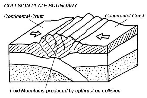
On 25th April 2015, another earthquake struck... this time in the Himalayan country of Nepal where the Indian Continental Plate meets and collides with the Continental Eurasian Plate. This type of boundary is called a Destructive Collision Boundary.
Diagram showing a Destructive Collision Boundary - DNo

Effects:


________________________________
CW Date: 3rd May 2019
Title:
How do the effects of Earthquakes vary between countries of different levels of wealth?
Entry Activity:
Nepal Video - HERE
Using your prior learning (notes) the textbook (pp14 to 17) and the video source viewed earlier, answer the following question:
Q.
To what extent can it be argued that poorer countries suffer more from natural hazards such as earthquakes? 6mks
Use PEEL to structure your answer, so...
Begin by deciding on your initial "Point"... check that your point is acceptable/appropriate by running it past your neighbour or your teacher.
Complete by presenting "explanation" and "evidence" to support the point.
At the end, "link" back to the question... make sure it is actually answered.
What are the features and effects of earthquakes?
Entry Activity:
Key Terms:
Features (Review)
Copy
The power of an earthquake is measured using a seismometer. A seismometer detects the vibrations caused by an earthquake. It plots these vibrations on a seismograph.
The strength, or magnitude, of an earthquake is measured using the Richter scale. The Richter scale is numbered 0-10 with 10 being the greatest strength or magnitude.


What are the Effects of Earthquakes?
Earthquakes can destroy settlements and kill
many people. Aftershocks can cause even
more damage to an area.
It is possible to classify the effects of an earthquake into primary and secondary effects (as covered previously) Alternatively, we can also consider the following factors:
many people. Aftershocks can cause even
more damage to an area.
It is possible to classify the effects of an earthquake into primary and secondary effects (as covered previously) Alternatively, we can also consider the following factors:
- social effects (the impact on people)
- economic effects (the impact on the wealth of an area)
- environmental effects (the impact on the landscape)
See bitesize source for types of effects: HERE
Factors affecting the impact of an earthquakeand factors affecting
Factors affecting the impact of an earthquakeand factors affecting
2. The higher on the Richter scale, the more severe the earthquake is.
3. Level of development (HIC or LIC) - HICs are more likely to have the resources and technology for monitoring, prediction and response.
4. Population density (rural or urban area). The more densely populated an area, the more likely there are to be deaths and casualties.
5. Communication - accessibility for rescue teams.
6. Time of day influences whether people are in their homes, at work or travelling. A severe earthquake at rush hour in a densely populated urban area could have devastating effects.
7. The time of year and climate will influence survival rates and the rate at which disease can spread.
Action:
Complete Skills Pod 13 from Kerboodle
Complete Skills Pod 13 from Kerboodle
CW Date: 10th May 2019
Title:
Review from Cover Lesson:
Why live in an Hazardous Zone?
Why live in an Hazardous Zone?
Iceland - HERE
Source below - HERE

Human Activity around Mt Merapi in the Philippines.

Action:
1. Label the land uses by arrowing onto the photo provided.
1. Label the land uses by arrowing onto the photo provided.
2. Write a short explanation of why people live close to Mt Merapi.
CW Date: 10th May 2019
Title:
Reducing the risks from Tectonic Hazards
Notes:
There are four management strategies used to mitigate the effects of tectonic hazards:
1. Monitoring
2. Prediction
3. Protection
4. Planning.
Using page 20 of the text book to help, explain what each of the strategies involves.
Details from the text - read and discuss...
Activity:
(Questions Only Sheet - HERE)
Montserrat Eruption 1995 - HERE no longer available...
Alternative: https://www.youtube.com/watch?v=e5udh2ADP1Y HERE
CW Date: 24th Janaury 2018
Title:
Revision support for Exam on Friday P2
Recommended content:
- Tectonic theory/continental drift
- Evidence for continental drift
- Types of plate margins, features and associated tectonic hazards
- Effects of Tectonic hazards
- Responses to Tectonic Hazards
Skills:
- Map interpretation
- Describing patterns and distributions
- Analyses of statistical data
Continental Drift Theory and Evidence:
- Earth made up of Oceanic and Continental crust forming a number of "plates". The continental is lighter and thicker and can be imagined as "floating" over the Oceanic... Driven by convection in the mantle, the Continental plates have shifted position on the earth's surface over millions of years.
- Evidence for this includes contiguity (jig-saw fit) of today's continents...

- Other evidence includes plate margins and their features ie DoT, Fold Mountains; geological and fossil evidence separated by oceans; palaeomagnetism and sea floor spreading as evidenced by the relative age of rocks at mid and edge of oceans.
Plate margins:
Destructive (with and without Subduction)
Constructive
Conservative
Linking plates with tectonic events (EQs and Volcs):
Cloze about EQs and Vs - Use for revision:
Explain why the majority of Earthquakes and volcanoes occur at plate margins (4 marks)
Copy/complete the model answer below:
Earthquakes and volcanoes happen where the crust moves, is weaker and where molten rocks from the Mantle can escape to the surface. These are features of plate margins.
Earthquakes happen because... movement between plates caused by convection in the Mantle, occurs suddenly after sufficient stress has accumulated. Slippage between the plates releases energy in the form of seismic waves i.e. Earthquakes. Earthquakes happen at all types of plate margin and along fault lines associated with margins e.g San Andreas Fault in California, USA.
Volcanoes are places where... molten rocks escape onto the surface. This happens because subduction at Destructive margins melts parts of the crust which then leaks onto the surface through cracks and fissures to form volcanic mountains e.g. along the margin between the Nazca and South American Plates.
Volcanoes also happen where the plates are separating (Constructive margins e.g Mid-Atlantic Ridge). Here magma from eruptions fills the gap created between the plates.
Effects of hazards (pp 14/15):
Primary and secondary.
Factors affecting risk from hazards:
Increasing risk - pp 9
Other factors influencing effects:
1. Distance from the epicentre - the effects of an earthquake are more severe at its centre.
2. The higher on the Richter scale, the more severe the earthquake is.
3. Level of development (HIC or LIC) - HICs are more likely to have the resources and technology for monitoring, prediction and response.
4. Population density (rural or urban area). The more densely populated an area, the more likely there are to be deaths and casualties.
5. Communication - accessibility for rescue teams.
6. Time of day influences whether people are in their homes, at work or travelling. A severe earthquake at rush hour in a densely populated urban area could have devastating effects.
7. The time of year and climate will influence survival rates and the rate at which disease can spread.1. Distance from the epicentre - the effects of an earthquake are more severe at its centre.
2. The higher on the Richter scale, the more severe the earthquake is.
3. Level of development (HIC or LIC) - HICs are more likely to have the resources and technology for monitoring, prediction and response.
4. Population density (rural or urban area). The more densely populated an area, the more likely there are to be deaths and casualties.
5. Communication - accessibility for rescue teams.
6. Time of day influences whether people are in their homes, at work or travelling. A severe earthquake at rush hour in a densely populated urban area could have devastating effects.
7. The time of year and climate will influence survival rates and the rate at which disease can spread.
Responses to Tectonic hazards -Short and Long Term (pp 16/17).
- What are the responses?
- Why are responses different in different places (Level of development)
Available at end of this doc - HERE
CW Date: 14th May 2019
Title: Reducing the Risk from Tectonic Hazards.
Coverwork:
Resources:
GCSE Text Book pp 20/21
and
Worksheet provided: HERE
If there is time (Vid is 40 mins), show the following video (Tasks below)
Video: HERE
https://www.youtube.com/watch?v=uplu6DL9DoI
Kobe Earthquake 1995
WWW description:
Kobe Earthquake of 1995 Disasters Documentary - YouTube
https://www.youtube.com/watch?v=uplu6DL9DoI
Video for kobe earthquake▶ 41:46
21 Jul 2016 - Uploaded by Disaster Documentary National Geographic
The Great Hanshin earthquake or Kobe earthquake, occurred on January 17, 1995 at 05:46:53 JST
Tasks From the video:
List four factors that made the earthquake so damaging and two things that have subsequently happened/been learned that would reduce the impact of a future earthquake of this magnitude.
Title:
Reducing the risk from Tectonic Hazards
Entry Activity:
Key Terms:
Poss view the naked Science Super Volcano vid - Naked Science Super-volcano - HERE
2nd Feb - To complete from 42 minutes in... c. 7 mins left... discussion?
2nd Feb - To complete from 42 minutes in... c. 7 mins left... discussion?
Followed by...
With Reference to pp 20/21 of the text...
1. Complete the question Sheet - HERE (Reducing the risk from tectonic hazards)
then...
1. Complete the question Sheet - HERE (Reducing the risk from tectonic hazards)
then...
2. You are going to answer the following examination practice question (record the question):
"Using the images below and your own knowledge, assess how management strategies can be used to reduce tectonic hazard risk. [9 marks]"
"Using the images below and your own knowledge, assess how management strategies can be used to reduce tectonic hazard risk. [9 marks]"

Step 1: Unpicking the question
Using the images attached and your own knowledge , assess how management strategies can be used to reduce tectonic hazard risk . [9 marks]
BUG your question...

✓ Box the command word ("assess")
Assess:
Consider several options or arguments and weigh them up so as to come to a conclusion about their effectiveness or validity.
✓ Underline the following:
• the theme ("tectonic hazard risk")
• the focus ("management strategies")
• any evidence required ("images attached and your own knowledge" ie specific evidence from the source and your knowledge)
• the number of examples needed ("images" plural, so more than one)

✓ Glance back over the question – to make sure you include everything in your answer...
Check...
specific evidence
You must refer to evidence from the images and to your own knowledge of tectonic management strategies in your answer.
You must refer to evidence from the images and to your own knowledge of tectonic management strategies in your answer.
Command word
Assess Your answer must show that you have considered the evidence and made an informed judgement.
Assess Your answer must show that you have considered the evidence and made an informed judgement.
focus
The focus must be on specific management strategies which reduce the hazard risk. You must include more than one strategy in your answer.
theme
This question relates to the theme of the Tectonic hazards which is assessed in Paper 1, Section A of your GCSE exam.
This question relates to the theme of the Tectonic hazards which is assessed in Paper 1, Section A of your GCSE exam.
Step 2: Planning your answer

PEEL your answer...
Use PEEL notes to structure your answer.
This will help you to communicate your ideas to the examiner in the clearest way.
• Point – Make two or three points in detail, rather than lots of points in less detail. Don’t use bullet points.
• Explain – Give reasons by using sentence starters such as: ‘This is because …’, ‘One reason is …’.
• Evidence – Include facts and other details from named examples to back up your point. Each point – with explanation and evidence – should represent a separate PEE paragraph.
• Link – To link different points to each other, use PEE sentence starters such as: ‘Another important point is …’ or ‘Of more importance is …’. Make sure your conclusion also links back to the question.
Aim:
To understand that, although the Natural Events themselves cannot be prevented, people can undertake measures to reduce their negative impacts.
Trailer - HERE
Socrative - HERE?
NEW HAZARDS SECTION - WEATHER
CW Date: 7th February 2018
Collect 9 mark Q/Answers (on paper!)
2nd Feb - To complete from 42 minutes in... c. 7 mins left... discussion? - Done...
Title:
Introduction to Weather Hazards
Entry Activity:
Study the image... what does it show?

The thin blue haze cutting diagonally across the earth's surface is the Atmosphere... a relatively thin layer made up of a complex mixture of gases. It is within this layer that life exists on the planet and in which all our weather takes place.
What makes weather a hazard?
BBC - A year of extreme weather - HERE
Key Terms:
Atmosphere - The thin layer of gasses that surround the planet.
Insolation - Incoming Solar Radiation (Light from the Sun).
Weather - The day to day conditions of the atmosphere in relation to, for example, temperature, pressure or precipitation.
Climate - The long term, expected conditions of the atmosphere at a given time and place. Weather data collected over 30 years is averaged out to identify climates.
Extreme Weather - weather events or conditions that fall outside of normal expectations either in terms of intensity or duration.
The key driving force for the weather affecting the planet surface is energy from the Sun (Insolation).
Video Link - HERE
1. Energy (light and Heat).
2. Energy, heat and convection in the atmosphere.
3. Why does the amount of energy reaching the earth's surface vary with latitude?
4. How does this cause movement of the atmosphere?
Activity sheet - HERE
Then... complete tasks 2 to 5 below (text pp23)


GAC Video - HERE
CW 10W 23rd February 2017
10X 1st March 2017
Where and how are tropical storms formed?
Aims:
To be able to describe the global distribution of TRS, the conditions required and stages in their formation.
Source sheet (Storm tracks and Cross section) - Here
Vocabulary:
- Tropical revolving storm
- Hurricane
- Typhoon
- Cyclone
Video Clip:
TRS example - HERE (Show from 2:40m to 4:45)
Copy and complete using words below...
Wordbox:
rises Typhoons convection revolving Caribbean condenses
Tropical Storms are intense ............... storms that develop in tropical regions... they include Hurricanes, ................ and Cyclones. Their name depends on where they are i.e. Hurricanes in the W. Atlantic and ..................., Typhoons in the W. Pacific Japan and Philippines) and Cyclones in S.E. Asia (India).
Their basic initiation involves a severe .................... storm (like a thunder storm) in which warm moist air ............ As it rises, moisture ........................ (this is an exothermic reaction) and releases heat into the surroundings. This added (latent heat of condensation) increases the convective process and intensifies the storm.
10W completed up to here on 24th
1. Use the map provided to describe the distribution of tropical storms (Give the general, global pattern of location and then provide more detailed exemplification)

10X - 2nd March (those present will be teaching those who were absent) - Defining, locating and explaining formation.
Everyone in 10X continue from here 2nd march 2017 once above is done:
2. Complete the activities from pp 25 of the text.

Formation of TRS - HERE
Formation of a HURRICANE - HERE
Hurricane Katrina - Here
10X - Finish watching Katrina (from start).
Student teaching (attendees of 1st March to those at musical) - See LP prepd... HERE
3. Using the cross section provided (or draw your own) and the information on pp25, produce a sequenced (1, 2, 3 etc) annotated diagram to describe the formation of a tropical storm.
4. Write a sentence using two of the key vocab. terms below... it has to be both sensible and true!
- Tropical revolving storm
- Hurricane
- Typhoon
- Cyclone
5. What are the features of Tropical Revolving Storms?
Using the illustration in the text pp 25 copy provided, describe the features of TRFs and the changing weather that would accompany the passage of such a storm.

Ref pp 26.
Read through the information about distribution, frequency and intensity.
Define the three key terms.
Complete the questions 1 to 3 inclusive.
HW Assigned on Kerboodle (3) Due 9th March
CW 10W 6th March 2017
10X 8th and 9th March 2017
Title:
Tropical Revolving Storms - Review and Consolidation.
If not already done, complete activities 1 to 3 inclusive on pp 26.
Then,
Activity sheet - HERE
Hurricane Intensity check

Typhoon Haiyan - Case Study - HERE (PO as A3)
Video - HERE (53min)
CW 10X 16th March 2017
10W 20th March 2017
Title:
How to mitigate the effects of Tropical Revolving Storms.
Complete the activities on the sheet provided - HERE10W notified about 9 mark question and advised to prep... shared the list of prim and sec points in Friday lesson (17th March)
10W to complete activities NL (Friday 24th March 17)
CW 10X 20th March 2017
10W
Title:
Feedback re. 9 mark question:
- Most, although not ALL answers referred to the case study. Absence of a named case study limits marks to level 1!
- Factual information regarding general effects was, on the whole good and appropriate.
- Statistical information was often suitably accurate, but could be improved (some confusion about values for dead, homes destroyed and homeless people etc)
- More general weakness was with respect to Primary and Secondary Effects... answers did not always accurately allocate the effects to the correct category.
Ideas/suggested improvements:
Intro:
Name the case study - Typhoon Haiyan, Philippines, November 2013.
Define Primary and Secondary effects.
Main:
Outline a selection of Primary and Secondary effects.
Include statistical facts to support.
Some elaboration is good.
Conclusion:
eg Deduction of viewpoint about the overall importance of primary/secondary effects...
Make a list of hazardous weather that we may experience in the UK?
-------------------------------------------------
HERE - Activity related to Effects/Responses and Prim/Sec + Imm and Long Term... to clarify (formative activity from 9 mark Q)
Flooding in the UK - HERE So... what is the hazard
Boscastle Floods - + 10 years on - HERE
So, Why does the UK experience such a variety of weather hazards? - Source sheet HERE
Cover Lessons (During As Level Field Study Residential)
Flooding case study - Somerset Levels 2014.
CW 10X 19th April 2017
10W April 2017
Title:
Review Activity (Post cover lessons and Easter vacation) - HERE
CW 10X 19th and 20th April 2017
10W 21st and 24th April 2017
Title:
On completion of the review and feedback, complete the mapping/skills activities related to the case study (ref pp 36/7)
Map and Photo sources for teaching/demo - HERE
CW 10X 26th April 2017
10W 24th April 2017
Completion of the Map Skills work from previous session... then...
CW 10X 27th April 2017
10W 28th April 2017
Title:
Review previous work:
Return review work and Feedback final question.
Tabulate the Responses, Explanations and whether immediate or longer term.
GPOP: HERE
Video Source - 1947: HERE
CW 5th May 2017
Extreme weather in the UK (continued)
Timeline Activity:
Using the photographic source sheet provided and information from the text, complete the activity below...
1. Draw a time line to describe the extreme weather events in the UK since 2000. Use text boxes to describe the impacts of the events and illustrate your time line using the photo source sheet provided. Add any recent events.
HW: Complete timeline for NL (Resource Sheet - HERE)
Reading:
Read the text (page 39) and the article provided ("Are extreme weather events on the rise?") - HERE
Read, discuss and annotate the above. Note the process/skill of graph interpretation (Skills development).
Once this is completed, attempt question 3 from pp 39 and then the Practice Question.
10W - HW:
Write a paragraph or two to explain whether you agree that climate change is causing more extreme weather (evidence!).
HW:
View the items in the BBC Timeline about extreme weather events since 1947:
www.bbc.co.uk/timelines/zcwj2hv
CW 10X 4th May 2017
10W 8th May 2017
Climate Change - Paired Working/Investigation
Using the source sheets provided and any additional sources that you are able to obtain - Complete a short presentation to outline the following:
- The Evidence for climate Change
- The potential effects of climate change
- How people can respond to the threat/s posed by climate change.
Source Sheet - HERE
10X to complete above NL (10th May 2017)
Learning Check - HERE
Note assignments re management of hazards on CR in 2017.
Assessment - See Kerboodle "Natural Hazards - On your Marks". Well structured and develops skills of exam response/maximising marks (DNo@Sept 2017)
No comments:
Post a Comment
Note: only a member of this blog may post a comment.