
Lesson 1: Introduction.
Aims: to gain an appreciation of what is meant by the "Coastal Zone" and to begin to understand the processes operating and changing the landscape in these environments.
Although often referred to as a line, the Coastal "Zone" is often a broad band of transition between marine and terrestrial environments. The width of this zone varies depending on the TIDAL RANGE which may be measured in kilometers or measure only a few meters or less.Independent enquiry: Why does the tidal range vary from place to place?

Question: What do you think the people shown are doing (they are NOT on holiday!
As a transitional zone between land and sea, the coast is dynamic and subject to the effects of both land and sea processes. For Geographers, it is a place where things happen relatively quickly and where landscapes are oftem dramatic... this latter factor, presumably also accounts for its attraction to recreational visitors.
Waves
The most important medium of change at the shore are waves. They play a significant role in erosion , transport and deposition in these places.
In discussing and thus understanding waves, we need to know a few of their key features...
The Features of Waves:

a) Make a copy of the diagram above.
b) For each of the following terms (from the diagram above), write a brief definition:
- Crest
- Length/Period
- Height
- Trough
- Face
How are Waves Formed?Although some waves are the result of underwater volcanic eruptions or earth movements, we are concerned with the more common waves formed by wind blowing over the surface of water.
As this happens small circulations of the water molecules are set up due to friction between the moving air and the water. Over time and if the wind is strong enough, these will grow to form ripples, then wavelets and eventually waves.
The size attained by waves is dependent on the following factors:
- Strength of the wind
- Duration that the wind blows
- Fetch (the distance of open water over which the waves are able to develop - Obviously this is linked to the duration factor)
Activity:
Explain, in your own words, how each of the above factors affect the size of waves.
Activity:
Which part of the UK Coast is most likely to experience the largest waves? Explain your answer with reference to the above factors.
How do waves change as they enter shallow water?

This illustration from Doddlelearn illustrates how the form of waves changes as the enter shallow water. This happens because the bottom of the wave comes into contact with the sea bed and begins to be slowed down by friction. In consequence, the bottom of the wave slows down relative to the top, the whole wave is lifted up to become taller and its form becomes asymmetrical (instead of relatively symetrical as a deep water wave)... ie it "leans" forward. Eventually, the wave is so destabilised that it crashes forward and breaks. The "breaker" consisting of turbulent, foamy, white water rushes up the beach as SWASH. Having reached as far up the beach as the available momentum will allow, the wave then flows back to the sea as BACKWASH.

Test yourself:
Make sure that you are able to describe and explain how waves change as they move from deep to shallow water.
Activities:
Ref. page 145/6 of the core text.
a) Answer question 2d and 2e.
b) With the use of diagrams to assist you, describe and compare Destructive waves and Constructive waves.
Lesson 2: What sub-aerial processes affect the coast?
Aims: To understand and be able to describe/explain the key processes of weathering and mass-movement affecting the coast.
Sub-aerial processes is another term for "land processes" ie processes that operate in terrestrial environments. They include WEATHERING and MASS MOVEMENT and are defined as follows:Weathering: The disintegration of rocks in their original place at or close to the ground surface. It is largely caused by elements of the weather such as rainfall and changes in temperature.These processes are distinguished by operating "in-situ" ie without significant movement or relocation (Note: weathering is thus different from Erosion which does involves significant movement)
Mass movement: The movement of large amounts of material usually downhill under the influence of gravity.
There are three categories of Weathering affecting the coast as shown on the illustration below.
Activity 1:
Print out a copy of the illustration and, using the www to help you, write a definition of each in the boxes and give an example.

Activity 2:
The diagram below (Source: AQA Geography for GCSE A) shows the four types of mass movement. Make a careful copy of each diagram, use the text book (page 147 to name the type of mass movements and provide an explanatory caption for each.

Activity 3:
Complete the activities on the following diagram. You will need to refer to the core text page 42-3.

Activity 4:
Can you name the processes illustrated below?

Using a series of up to three sketches to help, explain how Freeze-thaw operates including the conditions necessary for it to take place.


Use the Progress Check below to test your core knowledge...

Lesson 3: What marine processes affect the coast?
Aims: To understand and be able to describe/explain the key processes of erosion, transport and deposition affecting the coast.
Erosional ProcessesActivity:
Print out the diagram below and, using page 148 of the core text or the table below), describe/explain each of the processes. You must learn each of these thoroughly.

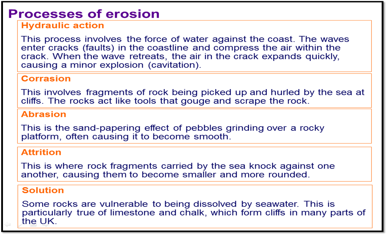
should be added to the diagram above... to test your understanding, see if you can identify the places in the following cross section that each process is most likely to take place... two have been done for you and they are colour coded to distinguish between erosion and weathering processes.

Transportation Processes:
Transportation is defined as the relocation or movement of sediments from one place to another. In the coastal zone this movement may result from tidal rising and falling, currents that flow along the shore and, of course by waves. Waves are our particular concern at GCSE (Note the same set of transportation sub-processes take place in rivers... so this knowledge is transferable to that topic :)
| The processes of Transportation affecting the Coastal Zone |
Activity:
Make your own version of the above to show the four types of transportation.
1. For each of the processes above, suggest how you might know that it was taking place on a visit to the coast (Hint - you might need to use all your senses...).
2. What type of waves (Constructive or Destructive) do you thin might be most likely to transport material? Suggest reasons.
For both erosion and transport to take place, energy is required... In science, remember, energy is defined as the ability to do work... So, as energy diminishes, for example as a storm abates or waves enter a shallower or more sheltered part of the coast, material that was being transported begins to be dropped... or deposited. The largest material will be deposited earlier than progressively smaller material. The very fines material being carried in suspension may require very calm conditions indeed to settle out of the water.
Activity:
- Take a large glass jar with a screw-top lid, fill 2/3 with tap water and then add a couple (or more depending on the size of your jar) handfulls of garden soil. Place a lid firmly onto the jar and shake vigorously for 30 to 60 seconds and then leave for about one hour.
- Predict what will happen.
- Check your jar after an hour... where you right? Look really closely, what do you notice?
- Can you explain your observations?
- How does this experiment help us to understand how deposition might affect the coastal zone? Explain.
(Useful tip... do not use your Mum's best pickling jars!)
Long Shore Drift
A favourite with teachers and examiners, this process involves transportation, but is a special case that combines several specific conditions, a sequence of events and which can result in a number of specific features in the coastal zone... It is also quite tricky to explain (for students...) Top tip: Learn it well!
Activity:
Make a copy of the illustration below and add further labels and annotations to complete it so that it fully explains how long shore drift operates. You will need to research using text books and/or the internet.
 |
| Tips for completion: You need to include information about Prevailing Wind Direction; The Angle that Waves Approach the Shore; The relative strength of Swash and Backwash; Beach Slope; Repetitive Action of Waves; Net Direction of Sediment Movement. |

Activity:
Study the photo (right) showing a part of Swanage Beach.
a) What is the wooden structure called?
b) Long shore drift takes place on this beach... how do we know?
c) In the picture... would the prevailing wind direction be from the left or right? Explain your answer.
d) The wooden structure is just one of many... why have they been constructed?

Additional Support...
Lesson 4:
What Features of Erosion are Found in the Coastal Zone?
Aims: To be able to recognise, name and explain the steps in the formation of the key erosional features at the coast.
Features are things that you can see... they are the result of the action of processes... ie stuff that happens. Thus a cliff is a feature. It results from the action of erosion on the coast combined with weathering and mass movement. Transportation may also play a role.
In learning the features of erosion and how thay are formed, it s a good starting point to understand that there are broadly three sets of features:
- Cliffs (plus wave cut notches and wave cut platforms)
- Headlands and Bays
- Caves, Arches, Stacks and Stumps
These sets of features are linked in an interesting way that should become clear to you if you build your knowledge in the listed order above (1 to 3)... So, Cliffs...
In this cross-section view of a cliff, a sequence of events eventually leads to collapse. Removal of collapsed debris by further erosion and transportation processes, re-exposes the bottom of the cliff to the action of waves. Thus the process of undermining and collapse/retreat can be repeated (Skills note - numbering the annotations ensures that the reader will follow the sequence in the correct order...)

Activity:

- Is Cliff Retreat taking place?
- How can you tell?
- Identify the key features (Cliff, WCN, WCN)
- Can you see any debris below the cliff?
- What would you call this indentation in the cliff?
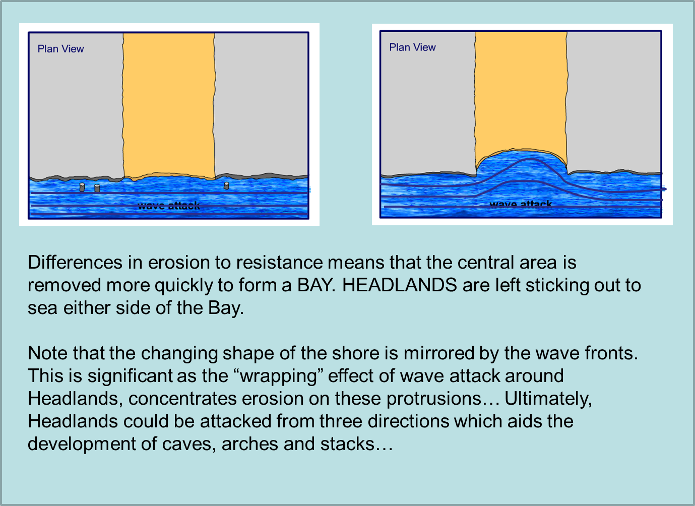
Headlands and Bays...
Headlands and bays are the result of differences in the resistance of the coast to erosion... some parts of the shore are stronger than others and these are left sticking out to sea as Headlands. Less resistant areas are eroded more quickly and form Bays.


Lesson 5:
What Features of Deposition are Found in the Coastal Zone?
Aims: To be able to recognise, name and explain the steps in the formation of the key depositional features at the coast.
Features of Deposition include:
Deposition of material being transported takes place when the energy required to move the sediment reduces. As a result particles can no longer remain in motion and are dropped onto the sea bed and may accumulate to form DEPOSITIONAL FEATURES.
What kinds of places or conditions lead to deposition?
a. Reduction in the energy of waves, for example as a result of calm weather.
b. Reduction in wave energy due the sheltering effect of say barriers and bays.
c. In bays, wave refraction also plays a role as the wave front deforms to match the shape of the coast. In bays, waves are effectively "stretched" or diffracted which dissipates their energy (this is the opposite of what happens as waves wrap around headlands and concentrate energy)
Beaches form in sheltered environments, such as bays. When the swash is stronger than the backwash, deposition occurs.
CW 8th December 2016
Title:
Features and processes of deposition (Continued)
1. What are the key features of deposition that you need to know?
2. What causes deposition?
3. Answer the questions using the resources provided.


Title:
Sea Level Change
Areas of the coast affected by marine processes depends on the level of the sea. Current global warming is raising sea level and thus re-positioning the parts of the coast affected.
Over the last 15 years it is estimated that sea levels have risen by 3mm per year. The latest estimates by the IPCC (Intergovernmental Panel on Climate Change) suggest that sea level will rise by between 28 and 43 cm by the end of the century.
Causes of Sea Level Rise:
Main - Thermal expansion of sea water as it becomes warmer due to heat transfer from the warming atmosphere.
Other causes - Ice melting from the land as Glaciers and Ice Sheets/Caps.
Using the annotated map pp 158, make a table detailing the effects of sea level rise on East Anglia.
What Features of Deposition are Found in the Coastal Zone?
Aims: To be able to recognise, name and explain the steps in the formation of the key depositional features at the coast.
Features of Deposition include:
- Beaches
- Bars
- Spits.
Deposition of material being transported takes place when the energy required to move the sediment reduces. As a result particles can no longer remain in motion and are dropped onto the sea bed and may accumulate to form DEPOSITIONAL FEATURES.
What kinds of places or conditions lead to deposition?
a. Reduction in the energy of waves, for example as a result of calm weather.
b. Reduction in wave energy due the sheltering effect of say barriers and bays.
c. In bays, wave refraction also plays a role as the wave front deforms to match the shape of the coast. In bays, waves are effectively "stretched" or diffracted which dissipates their energy (this is the opposite of what happens as waves wrap around headlands and concentrate energy)
Beaches form in sheltered environments, such as bays. When the swash is stronger than the backwash, deposition occurs.
Divergence
of waves also reduces the energy for transport in bays
Sometimes
sand from offshore bars can be blown onto the shore by strong winds.
In
such cases dunes may form
– such as at Studland on
the
Dorset
Coast.
CW 8th December 2016
Title:
Features and processes of deposition (Continued)
1. What are the key features of deposition that you need to know?
2. What causes deposition?
3. Answer the questions using the resources provided.


Title:
Sea Level Change
Areas of the coast affected by marine processes depends on the level of the sea. Current global warming is raising sea level and thus re-positioning the parts of the coast affected.
Over the last 15 years it is estimated that sea levels have risen by 3mm per year. The latest estimates by the IPCC (Intergovernmental Panel on Climate Change) suggest that sea level will rise by between 28 and 43 cm by the end of the century.
Causes of Sea Level Rise:
Main - Thermal expansion of sea water as it becomes warmer due to heat transfer from the warming atmosphere.
Other causes - Ice melting from the land as Glaciers and Ice Sheets/Caps.
Using the annotated map pp 158, make a table detailing the effects of sea level rise on East Anglia.
Coastal Management - Minehead, Somerset.


No comments:
Post a Comment
Note: only a member of this blog may post a comment.